In the ever-evolving landscape of construction and infrastructure development, technology continues to reshape traditional processes. One of the most transformative innovations in recent years is aerial 3D rendering, a cutting-edge technique that integrates drone technology and photogrammetry to generate detailed, three-dimensional visualizations of construction sites. This technology offers a comprehensive and highly accurate perspective of terrains, structures, and ongoing developments—something that conventional surveying methods often struggle to deliver with the same efficiency and precision.
Aerial 3D rendering has emerged as a game-changer for site analysis, enabling project managers, architects, and engineers to make faster, data-driven decisions. By providing real-time insights and reducing the reliance on manual inspections, it enhances planning accuracy, boosts productivity, and minimizes costly errors. As the construction industry pushes toward smarter, more sustainable practices, the adoption of aerial 3D rendering is not just a trend—it’s becoming a vital component of modern project execution.
What is Aerial 3D Rendering?
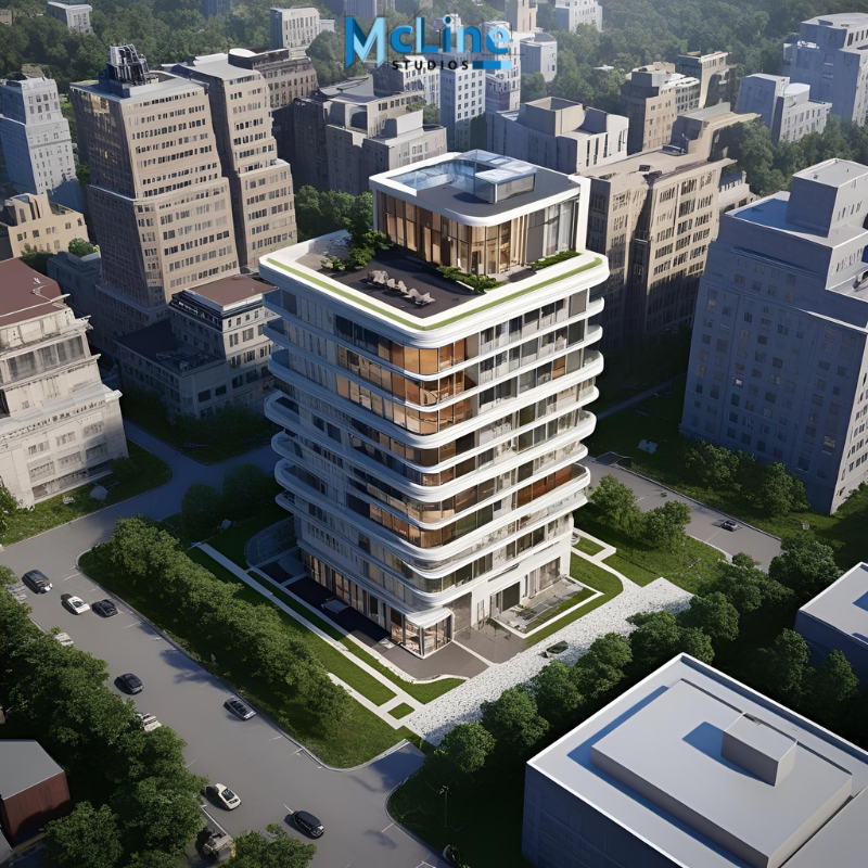
Aerial 3D rendering is a way to create realistic, computer-made images that show buildings, landscapes, or cities from above, like a bird’s-eye view. These images are made using special software that turns 3D models into lifelike pictures. This type of rendering helps people see what a project will look like before it is built.
Architects, city planners, and real estate developers often use aerial 3D rendering. It helps them show how a new building or neighborhood will fit into the surrounding area. For example, if someone wants to build a shopping mall, aerial 3D rendering can show how the mall will look with nearby roads, trees, and other buildings.
The rendering shows many details, like lighting, shadows, cars, people, and even the texture of roads and rooftops. This makes the image look very real and easy to understand. Aerial views are useful because they give a full picture of the project, not just one small part.
This kind of rendering is also great for marketing. It helps investors and buyers imagine the final result, which can lead to faster sales and better support for a project.
In short, aerial 3D rendering is a powerful tool that shows big projects from above clearly and realistically. It helps everyone involved—designers, clients, and the public—see and understand the project before it is built.
The Role of Site Analysis in Construction
Site analysis is a very important step before starting any construction project. It means studying and understanding the land where the building will be made. This helps builders, architects, and engineers make smart decisions and avoid problems later.
During site analysis, experts look at many things. They study the shape and size of the land, the type of soil, and the slope or flatness of the area. They also check the weather, wind direction, sunlight, and water flow. All of this information helps them decide where to place the building and how to design it in the best way.
Site analysis also includes checking nearby buildings, roads, trees, and other natural features. This helps the team make sure the new building fits well with its surroundings. They also look at rules and laws for construction in that area, which is very important for safety and legal reasons.
Another key part of site analysis is understanding the needs of the people who will use the building. For example, if the building is a school, it should be in a quiet and safe area with good access to roads.
In short, site analysis helps find the best way to build on a piece of land. It helps avoid future problems, saves money, and makes sure the building is safe, useful, and comfortable. Construction can face delays, higher costs, and design issues without site analysis.
How Aerial 3D Rendering Transforms Site Analysis
Aerial 3D rendering is a modern tool that is changing how experts study and understand land and building sites. It uses drone or satellite images to create lifelike, three-dimensional views of an area. These 3D models give a clear, detailed picture of the land, buildings, trees, roads, and other features.
In the past, site analysis was done using flat maps, drawings, or photos, which could miss important details. Aerial 3D rendering makes it easier to see the shape of the land, the height of buildings, and how different parts of the site connect. This helps planners, architects, and engineers make better decisions.
With 3D models, experts can spot problems early, like slopes, flood risks, or blocked views. They can also test how new buildings or changes will look and affect the area. This saves time, money, and effort in the planning and building process.
Another big advantage is communication. These 3D images are easy to understand for clients, local officials, and the public. Everyone can see the same picture and give feedback.
In short, aerial 3D rendering makes site analysis faster, clearer, and more accurate. It helps projects move smoothly from ideas to reality by giving a better understanding of the land and surroundings. This smart technology is becoming an essential part of modern design and planning.
The Future of Aerial 3D Rendering in Construction
Aerial 3D rendering is changing the way buildings are planned and built. This technology uses drones and special software to create 3D models of construction sites from above. These models show every detail of the land and structures, making it easier for teams to plan and manage projects.
In the future, aerial 3D rendering will become even more common in construction. Drones will be faster and more accurate. The software will get smarter, helping workers see problems before they happen. This means fewer delays and lower costs.
One big benefit is better communication. Everyone involved in a project—builders, engineers, and clients—can see the same 3D model. This helps them understand the project clearly and make better decisions.
Safety is another key area. Drones can reach high or dangerous places, so workers don’t have to. This reduces the risk of accidents on site.
As this technology improves, it will also help with environmental planning. 3D models can show how a building affects the land, water, and air around it. This helps teams build in a way that’s better for nature.
In short, aerial 3D rendering is making construction smarter, safer, and faster. As the tools become easier to use and more affordable, even small companies will be able to use them. This will lead to better buildings and stronger, more efficient construction teams. The future of building is in the sky—one drone flight at a time.
The Final Note
Aerial 3D rendering is revolutionizing the construction industry by bringing a new level of clarity, efficiency, and accuracy to site analysis. Combining advanced drone technology with powerful visualization tools, it allows stakeholders to assess terrain, plan projects, and communicate ideas more effectively than ever before.
From reducing risks and costs to enhancing environmental awareness and design precision, this innovative approach transforms how construction projects are executed.
As the technology continues to evolve, its adoption is poised to grow across projects of all sizes, making aerial 3D rendering an indispensable asset in building the smart, sustainable infrastructure of tomorrow.